Walking
Pages in Walking
- 1. You are here: Self guided walks
- 2. Information on walking
1. Self guided walks
Our borough has lots of beautiful green spaces, providing lots of walking opportunities for anyone looking to get outside and get active.
Banstead countryside circular walk
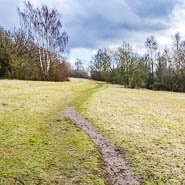 A pretty walk around the Banstead countryside close to Chipstead, walking through chalk grassland, mixed woodlands and open farmland, all rich habitats for a variety of wildlife, flora and fauna. Look out for the Narnia Trail. Great for bluebells
- Start and end address: Holly Lane free car park, Chipstead
- Car park postcode: CR5 3NR
- Difficulty: challenging terrain
- Distance: 5 miles, 8 kilometres
- Type of walk: circular
- Approximate time: 3 hours
- Accessibility: several kissing gates, bridle gates plus some steps and steep slopes
- Facilities: None on the route, shops in Chipstead village or The Ramblers Rest pub on Outwood Lane
- Ordnance Survey Map: 146 Dorking, Box Hill and Reigate
Map and directions for Banstead countryside circular walk (Surrey County Council)
Banstead Wood nature trail
A 3 mile (5 kilometre) circular walk discovering the hidden secrets and natural wonders of Banstead Woods, 250 acres of ancient woodland. Banstead Woods' recorded history stretches back for nearly a thousand years, to the time of the Domesday Book in 1086. Please note: This walk follows permissive footpaths which cross public and private land. Information is included for your interest, but please respect people's privacy, keep dogs under control and remember the Countryside Code.
- Start and end address: Holly Lane, Banstead, Surrey CR5 3NR
- Difficulty: fairly easy
- Distance: 3 miles, 5 kilometres
- Type of walk: circular
- Approximate time: 2 hours
- Accessibility: several slopes and there are kissing gates at the start and end of the walk. Some paths can be muddy in winter and wet weather.
- Ordnance Survey Map: Explorer 146 Dorking, Box Hill and Reigate
More about Banstead Woods nature trail and the Narnia trail can be found on: Reigate Society: Walks.
East Horley circular walk
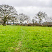 A flat circular walk taking you on a journey through time when new meets old and built-up areas merge with farmland, streams and woodland. You'll encounter World War II pillboxes, hints of the tanning industry and the mysterious site of Thunderfield Castle.
- Start and end address: The Farmhouse pub, Ladbroke Road, Langshott
- Car park postcode: RH6 8PB
- Difficulty: moderate terrain
- Distance: 6 miles, 9.5 kilometres
- Type of walk: circular
- Approximate time: 3 hours
- Accessibility: not suitable for wheelchairs or buggies due to several steps, gates and stiles
- Facilities: no toilets or picnic spots on the route itself. Refreshments and toilets are available at The Farmhouse pub
- Ordnance Survey Map: Explorer 146 Dorking, Box Hill and Reigate
Map and directions for East Horley circular walk (Surrey County Council)
Reigate Hill
 Enjoy an exhilarating walk across Reigate Hill and learn how man has influenced the history on the hill.
- Start and end address: National Trust Margery Lane car park. Non-members charge
- Car park postcode: KT20 7BD
- Difficulty: moderate terrain
- Distance: 3.3 miles, 5.28 kilometres
- Type of walk: circular
- Approximate time: 2 hours
- Accessibility: challenging, not suitable for wheelchairs and pushchairs due to steps. Fairly level paths with steep descent on a chalk path
- Facilities: Wray Lane car park. Open 9am–5pm
Map and directions for Reigate Hill walk (National Trust website)
Reigate mills and pillboxes circular walk
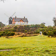 A circular walk from Reigate Heath with views across the North Downs, passing Reigate Heath windmill, Wonham Mill and pillboxes built during the Second World War.
- Start and end address: Reigate Heath bus stop on A25 junction at Flanchford Road
- Car park postcode: RH2 8AB
- Difficulty: moderate terrain
- Distance: 4.5 miles, 7 kilometres
- Type of walk: circular
- Approximate time: 2 hours
- Accessibility: several kissing gates and stiles. Parts of the route can be muddy
- Facilities: The Black Horse and The Skimmington Castle pubs near the start of the walk
- Ordnance Survey Map: Explorer 146 Dorking, Box Hill and Reigate
Map and directions for Reigate mills and pillboxes circular walk (Surrey County Council)
Reigate Town History Treasure Trail
Follow the historic treasure trail through Reigate town centre which was published in 2013 as part of the 150th anniversary celebrations of the Royal Charter of 1863, which made Reigate into a Municipal Borough.
- Start and end address: starts in Priory Park (RH2 7RL) and finishes at Reigate castle (RH2 0AP)
- Approximate time: 1 hour
- Difficulty: moderate terrain (fairly level easy paths until the final part of the trail, cobbled alley and Donkey Steps)
- Accessibility: challenging (final part of the trail not suitable for wheelchairs and pushchairs due to steep steps)
- Facilities: Priory Park café
Download map and directions for Reigate Town History Treasure Trail (PDF)